Browsed by
Month: October 2016

129. Rhoscrowdder – West Angle Bay

129. Rhoscrowdder – West Angle Bay

Distance: 9.6 miles

Max Altitude: 57 m

Min Altitude: 5 m

Height Gain: 178 m

Height Loss: 169 m

I won’t lie to you, it wasn’t exactly the best start to the day. Due to my trainer-saving detour around the Valero refinery yesterday, I had finished my day on the wrong side of the plant. So I needed to find my way back to the Wales Coast Path in order to get on my way again. Easier said than done though.

I could see it across a couple of fields so off I strode, making a beeline for the path. There was just one problem, well two actually – a huge bramble hedge and a double barbed wire fence. I took my pack off and chucked it over the barbed wire and then climbed over. My jacket got caught and a hole was ripped. Curses! I landed on the other side and prodded the ground with my foot. It was spongy. I was actually in a bramble-covered bog. Great! Three days ago I would have just waded through the ditch, but with my new trainers on that wasn’t even an option. I exhaled, stared at the sky and wondered what to do. There was no choice but to take the long way around. So back over the barbed wire I went, this time snagging my trousers. And back I trudged across the field towards the road again. A whole 3.5km wasted!

Still, I was back on the Wales Coast Path, and leaving the heavy industry behind me.

It was a fairly straightforward path towards Angle, nice and flat and took me through this field of cabbages.

I arrived in Angle to sounds from the Castlemartin firing range booming in the distance. The tide was out, so I began so walk around the headland.

The joy I felt when I got to The Old Point House pub! The even greater joy of seeing the words ‘walker’s lunch’! At spring tides this pub gets cut off from the mainland. I’m sure the people inside really hate it when that happens….(!)

Although I had walked past this pub on a previously, I’d never been inside before. It didn’t disappoint.

As well as the fire, various nick nacks had been encased in the walls.

There were interesting things everywhere, not least this bottle of booze, which had pride of place on the wall. I learnt why.

In 1878, the schooner, Loch Shiel, bound for Adelaide with a cargo of 100% proof whisky and gunpowder, was wrecked just off Thorn Island (which I would arrive at later in the day), near Angle. The Angle lifeboat was launched and the passengers and crew were all rescued. As the ship broke up, her cargo began to float ashore. The locals arrived at the beach to see what they could find and quickly realised what was contained in the wooden cases! In order to avoid Customs officials, many of the bottles were stashed in nearby caves, into alcoves in cottage walls, in attics or boarded up completely. Some lay hidden for decades. There were some fatalities though – three men died, two of them drowned while trying to recover whisky from the sea, the other from alcohol poisoning after drinking the 100% proof booze. Divers are still pulling up bottles to this day and it’s still drinkable. The bottle on the wall is an original recovered from the Loch Shiel.

After deciding that this is one of the finest pubs on the Wales Coast Path so far, I got on my way reluctantly. I will be back to The Old Point House though.

I was pleased to see Stack Rock Fort in its full glory from the other side of the Haven. I continued walking, daydreaming about what it would be like to live there.

Moving through a gate I encountered this little fellow. I’ve never seen a sheep that resembles a teddy bear quite so much.

I heard a loud rumbling in the distance. On my right shoulder was the ferry on its way out of Pembroke Dock towards Ireland.

Another place I’ve previously walked past but never visited is Chapel Bay Fort. This was previously a military fort and is now a museum and cafe.

Built in 1891, it’s part of a series of defences along the Haven, some of which I’ve walked past and blogged about (included Stack Rock Fort!). Last year it was re-opened as a museum and cafe after having been restored.

There were interesting artefacts everywhere. Yet another place to return to.

As I proceeded around the headland I saw my ultimate home, even more so than Stack Rock Fort – Thorn Island, site of the Lock Shiel shipwreck.

This is also one of the former military defences of the area. The fort was built in 1854 with a casemated battery of nine guns. When it was decommissioned after World War Two, it became a hotel, accessible only by boat. It went on sale in 2011 and was snapped up quickly by the current owners. Who could blame them?

With my head filled with daydreams, I proceeded towards the western side of Angle.

I continued around West Angle Bay. My progress was hindered at one point by this friendly wild horse. After some nose petting, he let me pass.

Within a couple of miles, my phone conked out. I think it was the cold. I debated whether to carry on or turn back. I decided to walk the two miles back to Angle rather than proceed. The next stretch was tough and remote and I didn’t want to be caught out without communications so I did the sensible thing (I’m sure my mother reading this will be delighted).

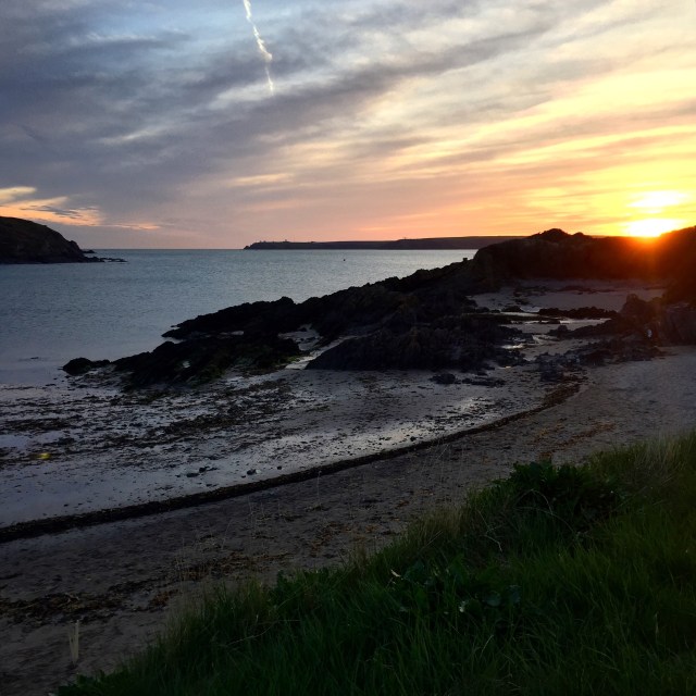
A little disheartened at my retreat, I sat on the shore eating a Welsh cake. My spirits soon lifted as I watched the sun disappear over Pembrokeshire.

128. Penfro (Pembroke) – Rhoscrowdder

128. Penfro (Pembroke) – Rhoscrowdder

Distance: 11.1 miles

Max Altitude: 80 m

Min Altitude: 10 m

Height Gain: 305 m

Height Loss: 306 m

After a day off for medical purposes, I arrived back on the trail.

I had found myself a new pair of trainers on my day off. The treads on the others had worn down so much that it was like wearing slippers.

My walk started beside Pembroke Castle. The Wales Coast Path runs alongside it, almost right the way around.

This bench was placed here to commemorate the birth of Henry Tudor, who would become Henry VII of England. It was good of them to put a bin there too. Handy.

I left Pembroke and followed the road out of the town for ages, walking on the pavement. I’d had a good look around the town before I got going.

It wasn’t the most inspiring of paths. I walked urban areas and a housing estate until the path led me to a small country road. I could see the power station and traces of heavy industry around me.

Some scenes were more familiar than others. What would the Wales Coast Path be without cows?

I was being careful of my new trainers. Is it just me who doesn’t like getting new shoes dirty? I avoided mud as best I could and walked on tarmac and concrete if possible. I was determined to keep my new footwear clean for as long as possible.

I followed a road next to the power station which led me onto a forest trail, a muddy forest trail. No way! I turned back and walked on the side of the road, which led me on a path right next to the Valero oil refinery.

By the time I reached Rhoscrowdder, my feet were aching badly. However comfortable my new trainers were, they were not yet worn in and were starting to pinch my feet.

I stopped next to the church. For you Welsh poetry aficionados out there, this is where Waldo Williams composed the poem ‘Cofio’ in 1931. He was harvesting turnips at the time. There’s a remembrance plaque there to commemorate it.

I peeled my socks off to reveal some fresh blisters. I had managed to keep my trainers in pristine condition, but not so my feet, alas.

126. Aberdaugleddau (Milford Haven) – Penfro (Pembroke)

126. Aberdaugleddau (Milford Haven) – Penfro (Pembroke)

Distance: 13.7 miles

Max Altitude: 63 m

Min Altitude: 3 m

Height Gain: 354 m

Height Loss: 364 m

It was a windy day on the Wales Coast Path. My walk began in front of the memorial to a plane crash which happened during the Second World War. The memorial overlooks the site where Wellington IC, N2749, of 27 OTU, RAF Lichfield, crashed in the early hours of the 19th July 1942. There were no survivors.

I continued down Hamilton Terrace.

And I arrived at another memorial. This time a sculpture dedicated to the four workers who died in an explosion at the former Chevron oil refinery in 2001. 

The sculpture is made from bronze and stainless steel, with fossils embedded around the base.

A few metres further along the Wales Coast Path was a third memorial. This was a tribute to the fishermen of the area. The inscription read ‘thanks to them Milford Haven flourished’, which I thought was lovely.

I’ve heard many people complain about this stretch of the Pembrokeshire Coast Path, saying that it’s ugly and too industrial and so forth. And yes, maybe that’s true in many ways. However, today, to me, it looked glorious.

In another few metres I came to my fourth memorial of the day so far, and I had barely walked a couple of kilometres. This was dedicated to wartime mine laying operations and the port of Milford Haven.

I took a wrong turn and thought I’d found a fifth memorial. I hadn’t. It was a Celtic cross.

After rediscovering the correct route, I ended up at Black Bridge, crossing the tidal estuary.

From then it was a pretty dull trudge around the Dragon LNG terminal, which used to be an oil refinery. When I got to Llanstadwell I sat down and ate.

I found this sorry looking pair of discarded shoes. Would they ever be reunited with their owner?

I walked past houses along the side of the estuary until I got to the outskirts of Neyland at Brunel Quay.

in 1856 this place became the site for the western terminus of Isambard Kingdom Brunel’s Great Western Railway, hence the name. This whole area is dotted with information about the man himself and his most famous engineering projects.

Who knew that Brunel modelled himself on Willy Wonka though? Uncanny.

On the waterfront was this helpful plaque with all the various surrounding locations.

And I got my first glimpse of Pont Cleddau.

Prior to building of the bridge, the river Cleddau divided the area. The towns of Pembroke Dock on the south side and Neyland on the north side were less than 1 mile apart across the water but a 28 mile journey apart via road. Incidentally, the people of Aberdyfi and Borth still feel this pain (as do certain walkers who recently had to travel up and down the Dyfi estuary for two days!). The Pont Cleddau was opened in 1975 and these days costs a princely 75p to cross in a car. However, people on foot like me get to go over for free, which is marvellous.

First up though I had to walk across the smaller Westfield Pill bridge.

I arrived at the Pont Cleddau but started to wonder if someone was trying to tell me something with this omen hanging from a lamppost. I mean, it was a gusty day….

Across I went.

I got to the other side and carried on along the side of the water.

I was rather thrilled not only to reach this gun tower but also this multicoloured bench.

This is known as a Cambridge Gun Tower and was built in 1851 to protect the Royal Dockyard. It’s one of a chain of forts known as ‘Palmerston’s Follies’ built to encircle the Milford Haven waterway during the Napoleonic Wars. It’s now a museum, but it was shut when I walked past.

Passing through the town I spotted this rather timely piece of street art.

My stopping point for the evening was Penfro (Pembroke). In 1093 Roger of Montgomery built the first castle at the site when he fortified the promontory during the Norman invasion of Wales. I considered going in but it was too late in the day. Another for the return list.

Henry Tudor (the future Henry VII of England) was born here in Pembroke Castle in 1457.

I’ve seen many many memorials on my travels (not least today), and I’ve walked past hundreds of memorial benches in particular. However, I hadn’t seen a memorial bench dedicated to an English monarch until today.

My day was at an end. It wouldn’t be long until I was leaving the industrial parts of the Pembrokeshire coast. Barafundle, Manorbier, Tenby and Saundersfoot beckon….

125. St Ishmaels – Aberdaugleddau (Milford Haven)

125. St Ishmaels – Aberdaugleddau (Milford Haven)

Distance: 8.9 miles

Max Altitude: 56 m

Min Altitude: 1 m

Height Gain: 289 m

Height Loss: 271 m

->

My day started in St Ishmael’s. It was a short walk to find the Wales Coast Path at Monk Haven.

Monk Haven was a landing place centuries ago for traders and pilgrims on their way to St David’s.

Yet again, I was fortunate enough to be experiencing one of those perfect Pembrokeshire days.

Up and down the coast, everything looked so idyllic. The going underfoot was pretty easy too. Not too many ups and downs.

On the way, there were further signs of Pembrokeshire’s military past.

In the distance were the industrial areas of Aberdaugleddau (Milford Haven) and Doc Penfro (Pembroke Dock).

Arriving at Lindsway Bay, the Wales Coast Path was at its best. Quiet, sunny, remote.

There were just three people and a dog on the beach. Nobody else was to be seen for miles.

One of the best things about walking the trail at this time of year is the abundance of blackberries. The Wales Coast Path seems to be flanked by burgeoning brambles. My pace slows down as I pick off the fattest berries to gorge on.

I was certainly nearing the industrial and shipping zones, as I arrived at this radar station.

There were two men renovating a house right on the tip of the headland. This must be one of the remotest and weather-beaten dwellings in Britain. 

I had timed my walk so that I would arrive at Sandy Haven at low tide. It was very important else I’d have to take a detour of several miles away from the tidal estuary.

There used to be a set of stepping stones here to enable people to cross the river without getting their feet wet. It’s now been replaced by this new level crossing point.

And then it was onwards towards Milford. At South Hook Point I was level with Stack Rock Fort, a structure that has fascinated me ever since I saw it. A fort was built on these rocks between 1850 and 1852. Disarmed in 1929, it was first placed on the market in 1932 and sold for £160. In 2005 it was sold for £150,000. And I have to say, that I would love to own it!

Pondering a potential life on Stack Rock Fort, I arrived at the South Hook LNG terminal.

It may not have puffins or seals or golden sands, but sometimes simple industrial symmetry has its own sort of beauty.

The locals certainly have some quirks.

My finishing point was in the town itself, just above the marina. I was just in time for a beautiful Pembrokeshire sunset too.

124. St Ann’s Head – St Ishmaels

124. St Ann’s Head – St Ishmaels

Distance: 7.2 miles

Max Altitude: 58 m

Min Altitude: 1 m

Height Gain: 210 m

Height Loss: 225 m


It had been almost a fortnight since I had last walked.

To cut a very long story short, I had been fortunate enough to meet a retired consultant on St Ann’s Head, who was on holiday from London; this was all courtesy of my kind (and worried) host, Frans. When I told the consultant my symptoms (which I shan’t go into here for fear of boring you to death) he was very concerned and told me to see a doctor pronto. So off I toddled to my GP, who then dispatched me to the hospital for tests. They found my brain, my heart and a few other defects, but fortunately, nothing that can’t be helped with a series of injections and tablets. I will need some further investigations when I finish my hike, but all in good time…

Whilst all this was happening, I also caught some kind of fever, had a birthday and slept an awful lot.

Still shattered (and on my much-lamented rubbish feet) I decided to return to the trail in order to finish what I had started, and to hell with any medical conditions. Hurrah!

And so I found myself back on St. Ann’s Head on a beautiful Pembrokeshire day complete with blue skies and crisp sunshine. My welcome was complete when this fellow came to say hello. The Wales Coast Path just wouldn’t be the same without a bovine or two.

I fed the cow some grass and got on my way, past the lighthouses on St Ann’s Head.

It’s hard to believe that this is where the Sea Empress disaster happened in 1996. This entire coastline was awash with black oil for a long time afterwards, but twenty years on there’s no trace that it ever happened to the naked eye. Nature is amazing.

A short walk and I arrived at Mill Bay. In 1485, Henry Tudor arrived in this very location, with his 55 ships and 4000 soldiers landing at nearby Dale. Just two weeks later he defeated Richard III in the Battle of Bosworth Field to become Henry VII.

I struggled to imagine the scene here and wondered whether Henry got his feet wet coming ashore. He must have, I concluded.

My next destination felt very personal to me. I knew that my grandfather was stationed at St Ann’s Head with the Royal Artillery at the beginning of the Second World War. But I didn’t know much more than that, other than the fact that he operated the search light.

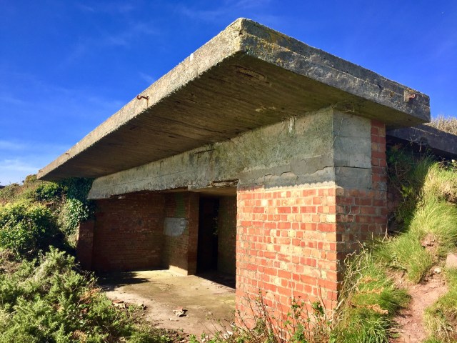
This bit is known as West Blockhouse Fort. The site is now derelict but there’s plenty of evidence of the buildings that would once have stood here, including concrete gun emplacements, bunkers and so forth. I imagined my grandfather here as a young man. I felt sad.


I continued on towards Dale. On the way in to the village, I walked past a series of driftwood sculptures by local artist, Sean Kehoe. I was impressed.

I couldn’t have asked for a better afternoon to be walking. The sea was calm at Dale and the tide was low.

It was a short walk across the Gann from Dale, which saved me a lengthy detour inland fortunately. I arrived at St Ishmael’s, my stopping point for the evening. I had managed more than seven miles under foot despite not feeling the best. All in all I was pleased and ended the evening with a smile on my face.

error: This content is under copyright.